On the Road in the Karakoram
The snowed-over Khunjerab Pass, at 4,934 meters, stands eerily silent on a freezing late autumn morning.
On the Pakistani side, a wooden house serves as a small customs office fronted by “the highest ATM in the world” – though you try a foreign credit card at your peril. The Chinese side boasts an intimidating, metal-plated James Bond-esque structure with no humans in sight.
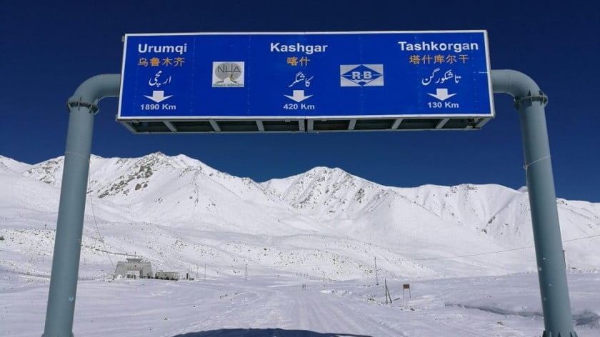
This is ground zero of the China-Pakistan Economic Corridor (CPEC), the point where the revamped, upgraded Karakoram Highway – “the eighth wonder of the world” – snakes away from China’s Xinjiang all the way to Pakistan’s Northern Areas and further south to Islamabad and Gwadar, on the Arabian Sea.
From here it’s 420 kilometers to Kashgar and a hefty 1,890 km to Urumqi, the capital of Xinjiang. But going south is where the fun really begins.

Traveling the Karakoram from Gilgit, the capital of the Northern Areas, to the Khunjerab and back is an exhilarating road trip along CPEC and its spin-offs. And it’s a crazy carousel.
Psychedelic Pakistani trucks, Chinese container road warriors – some trying to subdue the Khunjerab without chains on their tires – packed minivans plying the Hunza-Xinjiang route, Silk Road motels, the smell of curry interfacing with the best apricot juice in the world, roadside butchers, shacks advertising themselves as “Silk Road Investment & Credit Society Ltd,” many a Pak China Gateway Hotel, checkpoints consisting of a roadside table and a bunch of papers kept from flying away by pebbles, stashes of yuan crisscrossing rupees and dollars and messy, multi-level “people to people exchanges.”

It’s one of the greatest road trips on earth. And in geopolitical terms, it may be the greatest.
Mind the yaks
Karakoram North starts at the environmentally protected Khunjerab National Park, where yaks roam freely on the road and ibex and marmots are easily spotted nearby. But there are no Marco Polo sheep, much less snow leopards. (Though local Ismailis insist a few dozen reside in the park.)

The first serious pit-stop in the Karakoram is Sost, which used to be the Pakistani border in the old days – as when I traveled the road, twice, 20 years ago by jeep from Kashgar. Now, the bustling trade entrepot is the HQ of the Silk Road Dry Port Sost. Chinese lorries unload their cargo and Pakistani trucks take up the relay to transport the merchandise all across the nation. It appears modern and well-organized. Everything proceeds smoothly.

Snaking south, we pass right under the spectacularly receding Passu Glacier. In a nearby village, a funeral is in progress, with the crowd taking over the road alongside yaks and buffalos and interrupting traffic at will.

The upgraded Karakoram is an apotheosis of Pak-China Friendship Tunnels – all exhibiting the obligatory commemorative billboard extolling a geopolitical friendship soaring “higher than the highest mountain.”

This is CPEC in effect. It is astonishing when compared to the recent past. Between the Hunza and Gilgit rivers flowing parallel to impeccable asphalt worthy of an autobahn, a fiber optic cable runs all across the Northern Areas.
Chinese engineering has performed miracles. Around 160km south of the Khunjerab we drive around Attabad Lake, which totally submerged the road after a landslide in January 2010. For over five years there was simply no China-Pakistan overland trade, although some went via Kashgar-Gilgit flights. The solution by the China Road and Bridge Corporation had to be a tunnel – completed in 2015.

Trade along the Karakoram is bound to pick up – after years at less than 10% of total China-Pak trade, which tends to flow especially from Guangdong and Zhejiang provinces, not Xinjiang. Some stretches of the highway remain prone to constant landslides, rockslides or floods, which require a number of 24/7 rescue and maintenance teams. These are Pakistani, while the SUVs of the police in the Northern Areas have been supplied by China.
The heart of the New Silk Roads, or Belt and Road Initiative (BRI) infrastructure projects are road and railway lines. These do not cost a fortune per se; the expense is in the construction costs for bridges and tunnels. Russia spent over $4 billion on its Kerch Strait bridge to the Crimea. New Silk Road costs will be exponentially higher. Tunnels can be way more expensive than bridges.
Where the Himalayas rise
From the Karakoram it’s sometimes possible to catch a glimpse of the formidable Nanga Parbat – Kashmiri for “Naked Mountain,” later nicknamed the “Killer Mountain.” It has never been climbed in winter, and is actually a series of ridges which anchors the western Himalaya range, culminating in an ice crest at 8,126 meters above sea level. That is the ninth highest peak in the world and the second in Pakistan after K2.

As we approach Gilgit, the road signs – in English, Mandarin and Russian – say 468 km to Abbottabad (site of the Osama bin Laden endgame) and 583 km to Islamabad. Way down south, in less mountainous terrain, I’m told the odd rockslide gives way to occasional floods.
South of Gilgit, the Chinese once again are in frantic building mode, attacking the road starting from the Karakoram to the strategic Mecca Skardu. The road, according to local Ismailis, should be ready before 2020.

And then, on a bend of the revamped highway, the intersection of the Karakoram, the Hindu Kush and the Himalayan mountain ranges – bordering the confluence of the Gilgit River with the Indus, now flowing south all the way to the Arabian Sea – spreads before us. Nearly 85% of the Indus discharge happens between May and September, out of snow and glacial melt, propelling the monsoons. Abdul, the painter of the Karakoram, is applying the finishing touches to a white-clad viewing point.

The China-Pak embrace
The building of the original Karakoram – an engineering tour de force – took no less than 27 years and claimed the lives of over 1,000 Chinese and Pakistani workers.
The Karakoram Highway is much more than a road; it’s a rolling, graphic emblem of the China-Pakistan geopolitical embrace, surmounting all manner of economic, cultural, geological and security barriers over decades to the benefit of a strategic objective. And the strategic objective now is CPEC as the flagship BRI project.
At the recent opening ceremony of the China International Import Expo in Shanghai, where he was guest of honor, Pakistani Prime Minister Imran Khan described CPEC, including the Karakoram highway, as a “vital link” for China and Pakistan with the Middle East and Central Asia. “CPEC is a mechanism to connect China, the Middle East and Central Asia that also opens ways for fresh investment and paves the way for new markets,” he said.
Khan also reassured his hosts – as well as domestic public opinion – that his new government is engaged in deep, meaningful reforms to ensure transparency and accountability; virtual ghosts as far as Pakistani business is usually concerned.
“Pakistan has an array of resources, minerals and renewables amidst the most diverse landscape,” Khan said, adding that his country is a leading exporter of sports goods, medical instruments and IT products, and has promising, 100 million-strong human resources under the age of 35. So, the potential is immense.
Islamabad is all in on completing CPEC up to 2030, with projections of up to 3% added to annual GDP growth, as industrial output is bound to rise with more electricity courtesy of CPEC investments and more production coming from Chinese-style Special Economic Zones.
The big plan
CPEC’s Long-Term Plan (2017-2030), released one year ago, defines four priorities in Pakistan: Gwadar Port; energy projects; transport infrastructure (as in upgrading of the Karakoram); and industrial cooperation. Imran Khan’s government (see Part 1 of this report) is aiming for Pakistan to position itself, via CPEC, as the key hub uniting the overland Silk Road Economic Belt and the Maritime Silk Road.
This implies, geopolitically and economically, an even stronger, trans-regional, China-Pakistan alliance in contraposition to India and Washington. The US reaction to BRI in 2018 was to unleash a whispering campaign to try to discredit it. Beijing, for its part, expects India and Pakistan to at least discuss their political differences inside the Shanghai Cooperation Organization.
From now on, China’s far west and south – Xinjiang and Yunnan – have to become the top drivers of the Chinese economy. Upgrading their road, rail and energy infrastructure and closely linking them to South Asia and Southeast Asia is essential for China to keep growing – all that boosted by crucial energy connectivity via a gas pipeline from Turkmenistan, an oil pipeline from the Caspian in Kazakhstan, further massive gas shipments from Siberia, and, further down the road, a possible gas pipeline from Gwadar port to Xinjiang parallel to the Karakoram.
Will it work? The Karakoram, Hindu Kush and Himalayas have seen it all come and all go over multiple millennia. So why not? The upgrading of the greatest geological and geopolitical road trip on earth is a start.

By Pepe Escobar
Source: Asia Times